/prod01/wlvacuk/media/departments/media-and-communications/images-18-19/220325-Engineers_teach_thumbail.jpg)
/prod01/wlvacuk/media/departments/media-and-communications/images-18-19/Wolves-Story-Thumb.jpg)
/prod01/wlvacuk/media/departments/media-and-communications/images-18-19/220505-BAS9-School-Showcase-Resized.jpg)
/prod01/wlvacuk/media/departments/business-solutions/images/banners/business-we-back-you-500x250.jpg)
Have you ever wondered why the Stirchley Chimney that stands out against the natural landscape in the town park came to be there? What did the town centre look like before Southwater? Ever admired the ingenuity of the Hay Inclined Plane?
There are many different local historical sites hidden all around Telford; often accessible by foot. These are prominent reminders of the time when industrial ironworks were thriving in the area.
Many will know Telford as part of the final wave of new town developments along with others such as Milton Keynes and Peterborough. In order to meet the housing demand as overspill from Birmingham, Telford was first designated on 29 November 1968 as Dawley New Town; merging the nearby small towns. Many residents have seen with their own eyes the development of the town and the process is also well documented.
However, the history of the area goes back long before the modern development as a new town. For example, the earliest record of Madeley was when it was acquired by Mildburga of Wenlock Priory in A.D. 727! In the Domesday Book survey, it was valued at only 50 shillings with a population of 30 households in 1086 (Open Domesday).
This region became a prominent region in ironworks through the 18th and 19th centuries. The most famous landmark is the Iron Bridge in the Ironbridge Gorge; a UNESCO World Heritage Site. The bridge warrants its own blog post as the first major bridge in the world to be made of cast iron and situated in the “birthplace of the Industrial Revolution”!
In this blog, we will explore the resources to help us to learn more about our community and to find out how we can visit the numerous sites which are of historical interest.
Before Telford
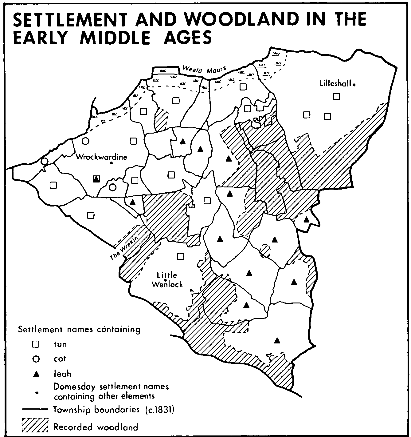
Three large estates at Wellington, Wrockwardine and Lilleshall existed by the 10th century. They are most likely the earliest settlements in Telford. Large areas around townships were deforested as more settlements were established. From the 12th century, large parts of the area were owned by six monastic houses. Urban developments in Wellington and Madeley were seen from the 13th century.
If we move a few hundred years later, this region had a significant part to play during the industrial revolution. It was Britain’s second largest ironworks by 1806. One man in particular, Abraham Darby III of Coalbrookdale, made a pivotal contribution to the technology of iron ore smelting. This led to the construction of the world-famous Iron Bridge, which was also designed by architect Thomas Pritchard. It was the first bridge in the world to be built of cast iron. To this day, you can see its influence on the landscape we see today.
Modern Telford
Dawley New Town was first designated as a site for a new town in January 1963. It was built as a development to tackle the housing crisis happening in Birmingham. The first homes occupied were on the Sutton Hill estate. Preparation for this estate began in 1965 with 2039 homes planned for sale and rent. The houses were priced at under £6000! The infrastructure of the surrounding towns was continuously constructed from the 1960s.
The TF postcode was introduced after the town was renamed Telford in 1768; the name that we are all familiar with today. The town is named after the civil engineer Thomas Telford. There were actually other suggested names including Dawelloak and Wrekin Forest City.
It wasn’t until 2014 that the £250 million regeneration of Southwater Square was completed to give us the town centre that we see now. Look below for more in-depth information of the modern Telford development. You can also find documentaries and footage of Telford in its young days. Maybe you can even spot yourself.
Documentary and Records of the development of Telford New Town
- From Dawley to Telford - Vimeo
- A History of the County of Shropshire: Telford - British History
- Telford on Film - Vimeo
- Glimpse into 60s Telford - Telford Live
- Telford Film - BFI
Walking Routes around Telford
There is no better way to experience all the local landmarks and to soak up both the history and ecology of the area than to walk it yourself. There are an abundance of industrial heritage sites surrounded by beautiful nature reserves. There are many different designated walking trails all over Telford that range from short walks to the Telford 50 miles route. Below are websites and leaflets that you can download to plan your walk today.
Telford and Wrekin Walking Routes
A comprehensive library of maps and leaflets for walking routes across the borough of Telford and Wrekin.
Discovering Shropshire's History
Map marking local building sites and buildings. You can find further information about each landmark.
The Telford T50 Trail is a 50 mile continuous walking trail that goes through parks, reserves and historic sites that make up Telford. There are signposts all along the route, with the T50 logo and a white direction arrow. It is easy to join the trail at any point from estates and bus routes, with food and accommodation along the way. The route is split into 7 stages; highlighting special places which are often unknown by the public.
Selection of walks that highlight local history and landmarks:

Telford - Past and Present
We would like to thank the following five students from Manchester University School of Architecture:
Mona Tamaru, Motunrayo Soyannwo, Sally Lofthouse, Yeside Sobowale, Xinbo Wang
who have produced a fascinating case study of Telford New Town. It explores how the design of the new town integrated with the existing historic settlements. It was published on 31st January 2020 and is entitled:
'A case study to assess the development and success of Telford'.
Click here to view